
The waterfront harbor and shops in a repurposed fish processing plant at Prince Rupert, the gateway to British Columbia, Canada, just 49 nautical miles south of the Alaska border on the Pacific Ocean
Prince Rupert is the gateway to British Columbia, Canada’s untamed north coast. Prince Rupert is the western terminus of the Trans-Canada highway, with the local section on Kaien Island built during World War II to connect to the mainland for the movement of men and materiel to the coast for fortifications and defense against a feared Japanese invasion (similar to the defensive fortifications work in Alaska, especially in Anchorage and the Aleutian Islands). Alaska is just 49 nautical miles to the north of Prince Rupert. Wildlife is plentiful, from majestic eagles and white Kermode or spirit bears to grizzlies and the largest concentration of humpback whales in North America. Over ten thousand years ago, this region was home to one of the largest settlements north of Mexico — archaeological traces of the indigenous Tsimshian nation abound and some of their descendants still live in the Prince Rupert area.
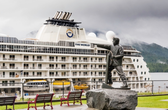
The Mariner’s Statue in the city park by the Cruise Terminal/pier in Prince Rupert, British Columbia, Canada, with our ship at dock

The Eagle Bluff B&B (bed and breakfast) is part of the colorful waterfront in Prince Rupert, British Columbia, Canada

Cow Bay includes the shops along the waterfront in the first photograph of this blog post, Prince Rupert, British Columbia, Canada; we had a very enjoyable dinner at Opa Sushi and an Italian-style lunch at Cow Bay Café, both in the neighborhood

Also in Cow Bay is Dolly’s seafood restaurant and the company’s large fish processing plant in the back (with the mural of whales on the end of the building), Prince Rupert, British Columbia, Canada
We had several good meals in Prince Rupert and enjoyed browsing and shopping in the local stores (with many works of art from local artists). During the one respite from the incessant fog and rain (sometimes quite heavy) we did a 3.3 mile/5.4 kilometer hike on the Butze Rapids Interpretative Trail, in a park northeast of town on the edge of Kaien Island. We were very fortunate to have as our guide a local resident, Jared Paolinelli, who founded the non-profit organization that has upgraded the trail and provided maintenance and guides for the past few years. He did an excellent job of introducing us to many plants and trees and the geology of the lush ecosystem that comprises the Butze Rapids section of the world’s largest temperate rainforest, along with some of the history of the local native Canadians (Tsimshian First Nation) and their culture.

The Butze Rapids Interpretative Trail was built in 1992 and traverses a coastal rain forest ecosystem through old growth forest, across bogs, wetlands and swamps carpeted with sphagnum moss and stunted growth pines, Prince Rupert, British Columbia, Canada

The Tsimshian tribe of Canadian native peoples mastered the art of peeling long strips of cedar tree bark that they then turned into ropes (pictured) and baskets tight enough to hold water; Butze Rapids Interpretative Trail, Prince Rupert, British Columbia, Canada

Gooseberries on the Butze Rapids Interpretative Trail, Prince Rupert, British Columbia, Canada

One of many sections of the Butze Rapids Interpretative Trail, Prince Rupert, British Columbia, Canada, that crossed “muskeg”, a North American swamp or bog consisting of a mixture of water and partly dead vegetation, frequently covered by a layer of sphagnum or other mosses

A series of seven trees have grown out of a “native log” (a fallen, dead tree) that serves as a root “anchor” in this section of muskeg along the Butze Rapids Interpretative Trail, Prince Rupert, British Columbia, Canada

Skunk cabbage (typically found in swampy soils) along the Butze Rapids Interpretative Trail, Prince Rupert, British Columbia, Canada; the Tsimshian First Nation people wrapped freshly caught salmon in the leaves to cook it

The abundance of lichen on trees and fallen logs is very typical in the rain forest on the Butze Rapids Interpretative Trail, Prince Rupert, British Columbia, Canada

The Butze Rapids Interpretative Trail, Prince Rupert, British Columbia, Canada, runs along the shore for some distance, coming parallel to the Butze Rapids
Butze (Reversing Tidal) Rapids were named by the local Tsimshian native Canadians in 1907 after Mr. A. Butze who was a purchasing agent for the Grand Trunk Pacfic Railway. The reversing tidal rapids are a natural feature caused by the ebb and flow of the tide through Fern Passage around Kaien Island. The phenomenon of the reversing tidal rapids is most dramatic when there are extreme tide ranges and during peak flows between high and low water. This is one of only two reversing tidal rapids in North America – the other is the Bay of Fundy, Canada. The island’s name, “Kaien”, comes from Sm’algyax for “foaming waters” caused by the reversing rapids in Fern Passage. The area is part of the traditional area of the Tsimshian First Nation and is the Tribal Territory of the Gitwilgyoot (People of the Kelp).

Kelp accumulating on the rocks along the shore of the Butze Rapids Interpretative Trail, Prince Rupert, British Columbia, Canada, just below the Butze Rapids

Butze (Reversing Tidal) Rapids are a natural feature caused by the ebb and flow of the tide through Fern Passage around Kaien Island, Butze Rapids Interpretative Trail, Prince Rupert, British Columbia, Canada

A colorful wild mushroom, Butze Rapids Interpretative Trail, Prince Rupert, British Columbia, Canada

This Pacific Silver Fir tree is estimated to be over 700 years old – seen on the Butze Rapids Interpretative Trail, Prince Rupert, British Columbia, Canada
Legal Notices: All photographs copyright © 2017 by Richard C. Edwards. All Rights Reserved Worldwide. Permission to link to this blog post is granted for educational and non-commercial purposes only.
