Exploring and Photographing by Sea – a Commemorative Post: # 1,001 (2017–2018)

2017 — As we climbed the hills of Wrangell, Alaska, we looked back and discovered that our ship had been nearly “swallowed up” by the dense sea fog in the harbor

It seems like yesterday when we flew to the Seychelles for our first journey as Resident/owners on our apartment ship, but here we are, 1,000 blog posts later.  To celebrate the milestone of blog post # 1,000 of “exploring and photographing by sea”, we have decided to do a retrospective of some of our favorite photographs from the past nine years.  This was a hard series of four posts to put together, culling through about 10,000 of our photographs that we have published over that period.  If a photograph gets you interested in that particular location (the site should be identified in the caption), use the “search” bar provided by WordPress when online — not when reading an emailed blog post — at:

richedwardsimagery.wordpress.com

Enjoy our retrospective!

2017 — Havana, Cuba Portrait #2

2017 — Mendenhall Glacier portrait (#6), Juneau, Alaska, USA

2017 — Suspension cables and the south tower disappearing in the fog, Golden Gate Bridge, San Francisco, CA, USA

2017 — The intrepid explorer and your blogger outside the Grand Hotel Manzana Kempinski in the heart of OLD HAVANA, Cuba, about to enter a 1950s classic car (a 1957 Chevrolet Bel Air) for a tour of the city

2017 — The men, half in masked costumes and the other half nearly naked (except for their penis sheaths, called nambas in Bislama), have begun the Rom Dance, Ambrym Island, Vanuatu

2017 — The mountain area around the Knik Glacier is filled with snow and small, mountaintop glaciers, Anchorage, Alaska USA

2018  — A typical small canal with an adjacent pedestrian sidewalk, Venice, Italy

2018 — A first course of local fish (a “Halibut Bombe”) and seafood, Hemelse Modder, Amsterdam, The Netherlands

2018 — A male polar bear on Arctic pack ice, north of Svalbard, at Latitude 82º 37’, photo #5

2018 — Gnålodden, Hornsund Fjord, Spitsbergen Island, Svalbard, photograph #13

2018 — Sand Dunes at Sunrise, Sossusvlei, Namibia, #3  — dune grasses highlighted by the early morning sunlight

Legal Notices: All photographs copyright © 2023 by Richard C. Edwards.  All Rights Reserved Worldwide.  Permission to link to this blog post is granted for educational and non-commercial purposes only.

Baluan Ceremonies, Papua New Guinea

The first ceremony we watched was the making of kava drink from the roots of the kava plants, Baluan Island, Papua New Guinea; the drink has sedative, anesthetic, euphoriant and entheige

The first ceremony we watched was the making of kava drink from the roots of the kava plants, Baluan Island, Papua New Guinea; the drink has sedative, anesthetic, euphoriant and entheigenic properties and is local to Fiji, Vanuatu and the Solomon Islands


Our welcome to Baluan Island, Papua New Guinea, called by the locals “The Rocky Island of Fruits”, was detailed in our previous blog post, “Our Welcome to Baluan Island, Papua New Guinea”.  During our visit we watched the last of the traditional ceremonial festivities on our three week expedition through Melanesia.  The first ceremony was the making of kava drink from the roots of the kava plant.  We had tasted kava a few years ago in Fiji (where it is also popular) and also earlier on this trip.  Kava drink has sedative, anesthetic, euphoriant and entheigenic properties and is local to Fiji, Vanuatu and the Solomon Islands.  We were treated to several dance performances where the music is the rhythmic beating of the local slit-gong, or garamut, drums (pictured, below).  Our final ceremony was the formal ceremonial wedding of a young couple (a “demonstration”, complete with the traditional costumes).


The first ceremonial dance was put on by children of the island, Baluan Island, Papua New Guinea

The first ceremonial dance was put on by children of the island, Baluan Island, Papua New Guinea


The drummers carve the slit-gong, or garamut, drums from hollowed out tree trunks, Baluan Island, Papua New Guinea

The drummers carve the slit-gong, or garamut, drums from hollowed out tree trunks, Baluan Island, Papua New Guinea


A group of the children dancers, after the dance, Baluan Island, Papua New Guinea

A group of the children dancers, after the dance, Baluan Island, Papua New Guinea


The lead boy dancer, Baluan Island, Papua New Guinea

The lead boy dancer, Baluan Island, Papua New Guinea


Two of the older girl dancers, Baluan Island, Papua New Guinea

Two of the older girl dancers, Baluan Island, Papua New Guinea


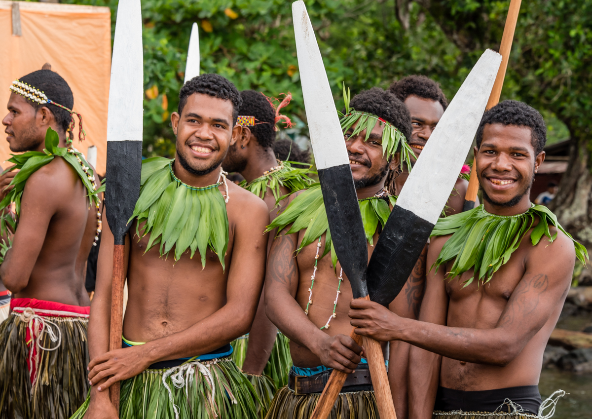
The men canoeists then put on a dance with their canoe paddles, Baluan Island, Papua New Guinea

The men canoeists then put on a dance with their canoe paddles, Baluan Island, Papua New Guinea


A small group of the canoeist dancers, Baluan Island, Papua New Guinea--

A small group of the canoeist dancers, Baluan Island, Papua New Guinea


The final ceremony was quite special – a reenactment of a Baluan marriage with traditional ceremonial costumes for the bride, groom and two bridesmaids, Baluan Island, Papua New Guinea

The final ceremony was quite special – a reenactment of a Baluan marriage with traditional ceremonial costumes for the bride, groom and two bridesmaids, Baluan Island, Papua New Guinea


The bridal dress and headdress, Baluan Island, Papua New Guinea

The bridal dress and headdress, Baluan Island, Papua New Guinea


A close up of the young bride with her pipe, Baluan Island, Papua New Guinea

A close up of the young bride with her pipe, Baluan Island, Papua New Guinea


The groom and a bridesmaid, Baluan, Papua New Guinea

The groom and a bridesmaid, Baluan Island, Papua New Guinea


As we sailed away from Baluan Island and Papua New Guinea and Melanesia, we reflected on how fortunate we had been to visit these wonderful islands and to be so warmly received by the islanders, many of whom have very little contact with Westerners over the course of a year.  Our memories of the people, the islands, the natural surroundings, the culture and the welcoming spirit of the region will remain with us for a long time.  Appropriately, we came across this quotation from Margaret Mead who spent much of her early adulthood doing research in this region, including Manus Island — next door to Baluan Island:

“as the traveler who has once been from home is wiser than he who has never left his own doorstep, so a knowledge of one other culture should sharpen our ability to scrutinize more steadily, to appreciate more lovingly, our own.” — Margaret Mead


Our Welcome to Baluan Island, Papua New Guinea

The Baluan ceremonial canoe paddled out to the ship to welcome us to the island and then came back to the beach to greet us as we came ashore on Zodiacs, Baluan Island, Papua New Guinea

The Baluan ceremonial canoe paddled out to the ship to welcome us to the island and then came back to the beach to greet us as we came ashore on Zodiacs, Baluan Island, Papua New Guinea


Formed by a now extinct volcano, Baluan Island is the southernmost of the Admiralty Islands.  The volcano’s eruption left rocks and boulders strewn all over the island, and the locals refer to it as the “palaces of stones.”  These stones mark the end of many unlucky visitors, who were sacrificed on these natural altars.  On our arrival we were greeted by a sign, “Welcome to Baluan, The Rocky Island of Fruits”.  The main foods on the island are fish and vegetables grown in the perfect growing volcanic soil


The warriors came down to the shore to greet us with a “war dance”, Baluan Island, Papua New Guinea

The warriors came down to the shore to greet us with a “war dance”, Baluan Island, Papua New Guinea


With this welcoming party, we wondered how welcome unfriendly visitors were in past times, Baluan Island, Papua New Guinea

With this welcoming party, we wondered how welcome unfriendly visitors were in past times, Baluan Island, Papua New Guinea


The islanders were enjoying watching their warriors welcome us, Baluan Island, Papua New Guinea

The islanders were enjoying watching their warriors welcome us, Baluan Island, Papua New Guinea


Quite a crowd gathered above the shore to watch the “welcoming party” greet us, Baluan Island, Papua New Guinea

Quite a crowd gathered above the shore to watch the “welcoming party” greet us, Baluan Island, Papua New Guinea


These girls were enjoying our welcoming, Baluan Island, Papua New Guinea

These girls were enjoying our welcoming, Baluan Island, Papua New Guinea


A great spot from which to watch the festivities, Baluan Island, Papua New Guinea

A great spot from which to watch the festivities, Baluan Island, Papua New Guinea


Another group of children who were enjoying our welcoming, Baluan Island, Papua New Guinea

Another group of children who were enjoying our welcoming, Baluan Island, Papua New Guinea


A number of islanders set up an informal open air market with produce, fish, fruit, jewelry and carvings for sale to their visitors (and to other islanders), Baluan Island, Papua New Gui

A number of islanders set up an informal open air market with produce, fish, fruit, jewelry and carvings for sale to their visitors (and to other islanders), Baluan Island, Papua New Guinea


One of the young dancers, Baluan Island, Papua New Guinea

One of the young dancers, Baluan Island, Papua New Guinea


One of the warriors who welcomed us to the island, Baluan Island, Papua New Guinea

One of the warriors who welcomed us to the island, Baluan Island, Papua New Guinea


Another of the warriors who welcomed us to the island, Baluan Island, Papua New Guinea

Another of the warriors who welcomed us to the island, Baluan Island, Papua New Guinea


Baluan is in Manus province of Papua New Guinea and Manus Island is located nearby.  This is one of the primary South Pacific regions where American anthropologist Margaret Mead did her primary research in the 1920s.  We were very fortunate to have three anthropologists traveling with us on the ship throughout our three-week Melanesia expedition.  We were introduced to Margaret Mead and her groundbreaking research and publications while we were in Papua New Guinea.  The following is a short summary of Mead’s work in the region.

“In 1925 she [Mead] set out for American Samoa, where she did her first field work, focusing on adolescent girls, and in 1929 she went, accompanied by her second husband, Reo Fortune, to Manus Island in New Guinea, where she studied the play and imaginations of younger children and the way they were shaped by adult society.  The Samoan work, published as Coming of Age in Samoa, became a best seller and has been translated into many languages.  This work presented to the public for the first time the idea that the individual experience of developmental stages could be shaped by cultural demands and expectations, so that adolescence might be more or less stormy and sexual development more or less problematic in different cultures.  It was addressed above all to educators, affirming that the ‘civilized’ world had something to learn from the ‘primitive.’  The Manus work, published as Growing Up in New Guinea, effectively refuted the notion that ‘primitive’ peoples are ‘like children.’  Different developmental stages, and the relationships between them, need to be studied in every culture.  Mead was thus the first anthropologist to look at human development in a cross-cultural perspective.” – www.interculturalstudies.org


This woman came over from Manus Island, the Provincial capital, to watch the ceremonies, Baluan Island, Papua New Guinea; her forehead tattoo is the marking that women on the island of M

This woman came over from Manus Island, the Provincial capital, to watch the ceremonies, Baluan Island, Papua New Guinea; her forehead tattoo is the marking that women on the island of Manus wear – each island has a distinct tattoo for their women


The provincial governor from Manus, the Honorable Charlie Benjamin, with two provincial government officials came over to Baluan Island, Papua New Guinea, to add their welcome to our exp

The provincial governor from Manus, the Honorable Charlie Benjamin, with two provincial government officials came over to Baluan Island, Papua New Guinea, to add their welcome to our expedition group


The island_s ceremonial canoe juxtaposed with our ship at anchor, Baluan Island, Papua New Guinea

The island’s ceremonial canoe juxtaposed with our ship at anchor, Baluan Island, Papua New Guinea


Baining tribe’s fire dance, Rabaul, New Britain Island, Papua New Guinea

The beginning of the Baining fire dance, Rabaul, Papua New Guinea, showing one of several masked tribesmen who will be dancing to the haunting, hypnotic rhythms tapped out by about a doz

The beginning of the Baining fire dance, Rabaul, Papua New Guinea, showing one of several masked tribesmen who will be dancing to the haunting, hypnotic rhythms tapped out by about a dozen men using bamboo poles to tap out the music on wood


Rabaul, built around Simpsons Harbour, is the home of the Tolai people, but the surrounding high Baining Mountains are the domain of the Baining people.  Leaving our ship late in the afternoon, we tendered to the Rabaul pier where we boarded small vans for the drive up the mountain (about 45 minutes on unpaved roads) to have a rare opportunity to witness the Baining’s tribe fire dance.  This dramatic display is a traditional part of ceremonies ranging from the celebration of a birth, the beginning of the harvest season, to the initiation of young men into adulthood.  During the ceremony, accompanied by men using bamboo poles to tap out haunting, hypnotic rhythms on wood, the Baining men dance and jump over red-hot coals and through the flames wearing elaborately decorated masks created just for the dance.  This dance is unique to the Baining tribe and Papua New Guinea.  We were extremely fortunate to be able to watch this ceremonial celebration in the mountains above Rabaul – a ritual that until recently was relatively unknown outside of Papua New Guinea.


Here one of the Baining men danced and jumped over red-hot coals and through the flames wearing an elaborately decorated mask created just for the dance, Baining fire dance, Rabaul, Papu

Here one of the Baining men danced and jumped over red-hot coals and through the flames wearing an elaborately decorated mask created just for the dance, Baining fire dance, Rabaul, Papua New Guinea; note that traditionally in the tribe no women were permitted to watch the dance ritual performance


The tribesman in the “crocodile” mask was by far the most energetic and daring of the dancers the evening we attended a ceremonial dance, Baining fire dance, Rabaul, Papua New Guinea

The tribesman in the “crocodile” mask was by far the most energetic and daring of the dancers the evening we attended a ceremonial dance, Baining fire dance, Rabaul, Papua New Guinea


Four masked dancers and a couple of men walking around the fire with a highly decorated “banner”, Baining fire dance, Rabaul, Papua New Guinea; there was a break in the rain and the

Four masked dancers and a couple of men walking around the fire with a highly decorated “banner”, Baining fire dance, Rabaul, Papua New Guinea; there was a break in the rain and the nearly full moon helped light up the ceremonial performance area


Here the “crocodile” dancer, with bare feet, energetically danced through the coals, kicking them up into the air for a “fireworks” display, Baining fire dance, Rabaul, Papua New

Here the “crocodile” dancer, with bare feet, energetically danced through the coals, kicking them up into the air for a “fireworks” display, Baining fire dance, Rabaul, Papua New Guinea; note the umbrellas, as it rained the first hour of the performance


At the former New Guinea Club building in Rabaul, that is now a museum, the masks on the left and right are from a Baining fire dance performance, Papua New Guinea

At the former New Guinea Club building in Rabaul, that is now a museum, the masks on the left and right are from a Baining fire dance performance, Papua New Guinea; traditionally, at the end of the dance the last rite was for the dancers to burn their masks – it remains taboo to sell or give non-tribal visitors a dance mask


Rabaul, Papua New Guinea

A panoramic view of Rabaul, Papua New Guinea, which was built on the edge of a flooded caldera, at a place called Simpsons Harbour and is ringed by volcanoes, including Mt. Tavurvur

A panoramic view of Rabaul, Papua New Guinea, which was built on the edge of a flooded caldera, at a place called Simpsons Harbour and is ringed by volcanoes, including Mt. Tavurvur, now misshapen after it erupted in 1994 and buried half the town under ash


Rabaul, Papua New Guinea, was built on the edge of a flooded caldera, at a place called Simpsons Harbour and is ringed by volcanoes.  The town was the capital of the province and widely regarded as the most beautiful town in the South Pacific until it was destroyed in 1994 when Mt. Tavurvur erupted.  The resulting ash inundated the town, with the weight of the ash causing the majority of the buildings to collapse.


The region around Rabaul, Papua New Guinea, remains seismically active; here hot springs come to the surface at 100 degrees C (212 degrees F) and flow into Simpsons Harbor; Mt. Tavurvur

The region around Rabaul, Papua New Guinea, remains seismically active; here hot springs come to the surface at 100 degrees C (212 degrees F) and flow into Simpsons Harbor; Mt. Tavurvur is in the background on the right


A close up of the hot springs, Rabaul, Papua New Guinea

A close up of the hot springs, Rabaul, Papua New Guinea


Rabaul has extensive World War II history, as it was the main Japanese headquarters in the South Pacific.  As a tourist destination, Rabaul is popular for SCUBA diving and for snorkeling sites and also offers a spectacular harbor. Because of its war-time history, it attracts many Japanese visitors.


During World War II Rabaul, Papua New Guinea, was seized by the Japanese and used as their headquarters; this is the two room underground bunker used as the working bunker office of the

During World War II Rabaul, Papua New Guinea, was seized by the Japanese and used as their headquarters; this is the two room underground bunker used as the working bunker office of the Admiral of the Pacific, Isoroku Yamamoto, the architect of the Japanese attack on Pearl Harbor, who on 18 April 1943 was killed by a U.S. P-38 Lightning over south Bougainville after taking off from Rabaul on an inspection tour


“Rabaul (the word means Mangrove in one of the local languages as it was built on a mangrove swamp) was the headquarters of German New Guinea until captured by Commonwealth troops during World War I.  The Australian administration was moved to Lae in 1937 after an eruption that caused over 500 deaths.  In January 1942, it was heavily bombed; on January 23 thousands of Japanese troops were landed.  By 1943 there were about 110,000 Japanese troops based in Rabaul and around 2,000 local women were forced into prostitution.  The Japanese army dug many kilometers of tunnels as shelter from the Allied air forces and many of these can still be seen today.


All of the region_s seismic activity is monitored an displayed on computer monitors at the Rabaul Seismic Observatory on a hill in Rabaul, Papua New Guinea, overlooking Simpsons Harbou

All of the region’s seismic activity is monitored an displayed on computer monitors at the Rabaul Seismic Observatory on a hill in Rabaul, Papua New Guinea, overlooking Simpsons Harbour and Mt. Tavurvur and Mt. Vulcan


“On 19 September 1994, Tavurvur and Vulcan volcanoes erupted, destroying the nearby airport and covering most of the town with heavy ash.  Fortunately the city’s inhabitants evacuated before the eruption and only a handful of people were killed.  Most of the buildings in the southeastern half of Rabaul collapsed due to the weight of ash.” – http://www.wikitravel.org


Mt. Vulcan and Mt. Tavurvur, photographed from the grounds of the Rabaul Seismic Observatory, Rabaul, Papua New Guinea

Mt. Vulcan and Mt. Tavurvur, photographed from the grounds of the Rabaul Seismic Observatory, Rabaul, Papua New Guinea


Rabaul is the home of the Tolai people, but the surrounding high mountains are the domain of the Baining people.  In the evening we were driven up the mountain (about 45 minutes on unpaved roads) to have a rare opportunity to witness the Baining’s tribe fire dance [see our next blog post].


We visited a cooperative factory (owned by 3 local plantations) that presses and processes and packages organic coconut oil, now available in export markets such as the United States, Ra

We visited a cooperative factory (owned by 3 local plantations) that presses and processes and packages organic coconut oil, now available in export markets such as the United States, Rabaul, Papua New Guinea; the equipment wasn’t photographed as it was hard to understand what was what…


Titiana Village, Ghizo Island, Solomon Islands

A typical home (raised on stilts) in Titiana Village, Ghizo Island, Solomon Islands

A typical home (raised on stilts) in Titiana Village, Ghizo Island, Solomon Islands


Titiana Village is somewhat unusual in the Solomon Islands – part of Melanesia – as after World War II the British brought down Micronesian workers from the Gilbert Islands for their coconut plantations on Ghizo Island, housing them in Titiana.  The children of the village performed some traditional dances for us during our morning visit.


The Micronesian grandparents of many residents of current Titiana Village, Ghizo Island, Solomon Islands, were brought down from the Gilbert Islands to work for the British on the coconu

The Micronesian grandparents of many residents of current Titiana Village, Ghizo Island, Solomon Islands, were brought down from the Gilbert Islands to work for the British on the coconut plantation that was the main industry of the Melanesian island


Young dancers relaxing before their performance for us in Titiana Village, Ghizo Island, Solomon Islands

Young dancers relaxing before their performance for us in Titiana Village, Ghizo Island, Solomon Islands

The girls who danced to the rhythmic (hand) drumming of the adults on a raised platform, nearby, spanned a wide age range, Titiana Village, Ghizo Island, Solomon Islands

The girls who danced to the rhythmic (hand) drumming of the adults on a raised platform, nearby, spanned a wide age range, Titiana Village, Ghizo Island, Solomon Islands


Many of the villagers joined our group of about 30 from the ship to watch the traditional dances by the children, Titiana Village, Ghizo Island, Solomon Islands

Many of the villagers joined our group of about 30 from the ship to watch the traditional dances by the children, Titiana Village, Ghizo Island, Solomon Islands


These kids were quite enthralled by the dancing, Titiana Village, Ghizo Island, Solomon Islands

These kids were quite enthralled by the dancing, Titiana Village, Ghizo Island, Solomon Islands


This “upscale” house has a corrugated metal roof – these are typically not in the center of the village, to minimize damage in a severe storm if the metal roof is blown off by high

This “upscale” house has a corrugated metal roof – these are typically not in the center of the village, to minimize damage in a severe storm if the metal roof is blown off by high winds, Titiana Village, Ghizo Island, Solomon Islands


These kids wished us a warm farewell, sitting on the back of one of our transport 4-wheel drive trucks with seats for us in the cargo area, Titiana Village, Ghizo Island, Solomon Islands

These kids wished us a warm farewell, sitting on the back of one of our transport 4-wheel drive trucks with seats for us in the cargo area, Titiana Village, Ghizo Island, Solomon Islands


Gizo, Ghizo Island, Solomon Islands

The Central Market in Gizo, on Ghizo Island, Solomon Islands, is adjacent to the main pier

The Central Market in Gizo, on Ghizo Island, Solomon Islands, is adjacent to the main pier


The islands of the New Georgia group in the Western Province of the Solomon Islands are rugged and lushly forested islets scattered in an intricate maze of winding waterways and turquoise lagoons.  Ghizo Island is no exception.  The small (population around 6,000) provincial town of Gizo is the second largest in the country and the capital of the Western Province.


Coconuts, yams, bananas, betel nuts, oil, etc. are popular products for sale in the Central Market, Gizo, Ghizo Island, Solomon Islands

Coconuts, yams, bananas, betel nuts, oil, etc. are popular products for sale in the Central Market, Gizo, Ghizo Island, Solomon Islands


“This area of Solomon Islands has had a history of headhunting.  According to local stories the Gizo tribe were notorious in this activity.  As a consequence the surrounding local tribes took the unusual step of joining together to obliterate the Gizo tribe.  The stories further relate that the only survivors were a Gizo woman and her son.  This event led to Ghizo island being declared as a property of the state, rather than the usual customary ownership prevalent in much of the rest of the Solomons.  As a secondary consequence becoming an administrative and business centre because of the relative ease with which registered land titles could be obtained.” — Wikipedia


Relaxing adjacent to the Central Market, Gizo, Ghizo Island, Solomon Islands

Relaxing adjacent to the Central Market, Gizo, Ghizo Island, Solomon Islands


We had the opportunity to walk around town and did some shopping at both the open air central market and, strangely enough, at the Gizo dive shop (Dive Gizo) — which deserves its reputation for offering the best arts and crafts (particularly wood carvings) that have been collected from all over the northern Solomon Islands, including the outstanding sculptures by the artisans living on the islands in Marovo Lagoon [see our previous post, “Sabulo Island, Marovo Lagoon, Solomon Islands”].


Very popular throughout the region, betel nuts are chewed with a touch of lime wrapped in a betel pepper leaf, Central Market, Gizo, Ghizo Island, Solomon Islands

Very popular throughout the region, betel nuts are chewed with a touch of lime wrapped in a betel pepper leaf, Central Market, Gizo, Ghizo Island, Solomon Islands


Adjacent to the Central Market, Gizo, Ghizo Island, Solomon Islands, is this small dry goods store

Adjacent to the Central Market, Gizo, Ghizo Island, Solomon Islands, is this small dry goods store


Separate groups of men and ladies were playing cards on the side of the Central Market, Gizo, Ghizo Island, Solomon Islands

Separate groups of men and ladies were playing cards on the side of the Central Market, Gizo, Ghizo Island, Solomon Islands


Walking into Dive Gizo on Ghizo Island, Solomon Islands, visitors who aren_t aware that this is the island_s premier arts and crafts store are surprised

Walking into Dive Gizo on Ghizo Island, Solomon Islands, visitors who aren’t aware that this is the island’s premier arts and crafts store are surprised


The selection of wood carved masks and sea life sculptures is quite broad, Dive Gizo, Gizo, Ghizo Island, Solomon Islands

The selection of wood carved masks and sea life sculptures is quite broad, Dive Gizo, Gizo, Ghizo Island, Solomon Islands


A stylized shark, carved by the islanders, for sale at Dive Gizo, Gizo, Ghizo Island, Solomon Islands

A stylized shark, carved by the islanders, for sale at Dive Gizo, Gizo, Ghizo Island, Solomon Islands


Sabulo Island, Marovo Lagoon, Solomon Islands

The intrepid explorer and your blogger enjoying a morning of kayaking in Marovo Lagoon, Solomon Islands

The intrepid explorer and your blogger enjoying a morning of kayaking in Marovo Lagoon, Solomon Islands


On our second day in the world’s largest atoll, Marovo Lagoon, we spent the morning kayaking and then visited the small island of Sabulo, where a small open air market was set up for us on this uninhabited island.  Artisan wood carvers from several nearby islands (who canoed over) presented their exceptional sculptures for sale.  These islanders are renowned for their mother-of-pearl inlays in the figures and masks they carve.  The inhabitants of the lagoon are regarded as the purveyors of the finest artisan products in the Pacific.  We made several purchases…)  We also had a chance to get a glimpse of lagoon islanders’ life.  In the afternoon we had more opportunities for snorkeling in the pristine waters that were teeming with sea life.


Two young islanders from Sabulo Island diving for fish, Marovo Lagoon, Solomon Islands

Two young islanders from a nearby island diving for fish, Marovo Lagoon, Solomon Islands


A young man out in his dugout canoe out for fishing, Marovo Lagoon, Solomon Islands

A young man out in his dugout canoe out for fishing, Marovo Lagoon, Solomon Islands


Kayaking around Sabulo Island, Marovo Lagoon, Solomon Islands

Kayaking around Sabulo Island, Marovo Lagoon, Solomon Islands


Several islanders in the very large open air market that was set up for our visit, Sabulo Island, Marovo Lagoon, Solomon Islands

Several islanders in the very large open air market that was set up for our visit, Sabulo Island, Marovo Lagoon, Solomon Islands


Locally woven fans were popular purchases (including this one bought by the intrepid explorer), Sabulo Island, Marovo Lagoon, Solomon Islands

Locally woven fans were popular purchases (including this one bought by the intrepid explorer), Sabulo Island, Marovo Lagoon, Solomon Islands


This wood carver specialized in the traditional head sculptures that are attached to the islanders_ war canoes (indicated by the vertical flat wood at the rear with three holes, enabli

This wood carver specialized in the traditional head sculptures that are attached to the islanders’ war canoes (indicated by the vertical flat wood at the rear with three holes, enabling attachment to the canoe), Sabulo Island, Marovo Lagoon, Solomon Islands; this one was purchased by your blogger and the intrepid explorer


Mid-day heat was a good reason for a nap by these young children attending the market with their vendor parents, Sabulo Island, Marovo Lagoon, Solomon Islands

Mid-day heat was a good reason for a nap by these young children attending the market with their vendor parents, Sabulo Island, Marovo Lagoon, Solomon Islands


These families (of artisan vendors) were preparing a fish fry for lunch in the shade by the coast, Sabulo Island, Marovo Lagoon, Solomon Islands

These families (of artisan vendors) were preparing a fish fry for lunch in the shade by the coast, Sabulo Island, Marovo Lagoon, Solomon Islands


The captain of the traditional Solomon Island-style canoe (see the next photograph) sold us this canoe that he carved, inlaid with mother-of-pearl, with a manta ray base to hold the cano

The captain of the traditional Solomon Island-style canoe (see the next photograph) sold us this canoe that he carved, inlaid with mother-of-pearl, with a manta ray base to hold the canoe, Sabulo Island, Marovo Lagoon, Solomon Islands


A traditional Solomon Island-style canoe with our ship in the background , Sabulo Island, Marovo Lagoon, Solomon Islands

A traditional Solomon Island-style canoe with our ship in the background, Sabulo Island, Marovo Lagoon, Solomon Islands


After all the snorkeling Zodiacs were loaded back on board, we sailed out of the lagoon-atoll in the late afternoon as the clouds were building up, Sabulo Island, Marovo Lagoon, Solomon

After all the snorkeling Zodiacs were loaded back on board, we sailed out of the lagoon/atoll in the late afternoon as the clouds were building up, Sabulo Island, Marovo Lagoon, Solomon Islands


Sunset over Marovo Lagoon, Solomon Islands

The sun setting over the northern islands of Marovo Lagoon, Solomon Islands

The sun setting over the northern islands of Marovo Lagoon, Solomon Islands


Heading northwest from Guadalcanal and Honiara, the bustling capital city of the Solomon Islands, we sailed overnight to the world’s largest atoll, Marovo Lagoon.  Here we had a casual afternoon of SCUBA diving and snorkeling in pristine waters away from the few villages on the atoll.  The sunset was tropical perfection – we had drinks on our deck and were thankful for the opportunity to explore such wonderful, remote areas of the planet on the ship.


A purple dusk seen from our apartment_s deck on our ship, anchored in Marovo Lagoon, Solomon Islands

A purple dusk seen from our apartment’s deck on our ship, anchored in Marovo Lagoon, Solomon Islands


The Marovo Lagoon has been proposed as a world heritage site and has received praise from a Pulitzer Prize winner.  No wonder, says Elio Stamm, considering the many miracles on offer, above the water and under the surface of the biggest saltwater lagoon in the world.  This is not a place where you need to look twice to realise its beauty.  No, the Marovo Lagoon, more than 100 kilometres [60 miles] in length, is the biggest saltwater lagoon in the world and is awe inspiring upon first sight.  As your small plane slowly emerges from the white clouds, you can see islands scattered across the horizon.  The intensity of the colours is outstanding.  The green of the more than one hundred small, and mostly inhabited islands, the blue of the deeper parts of the sea and the white of the shallow coral reefs make you understand where the Solomon Islands flag got its colours from.  The Marovo Lagoon is a double barrier reef enclosed lagoon, which in practise means a chain of coral reefs and islands that encircle the big Vangunu Island.  The 12,000 people living in Marovo’s 70 villages refer to Vangunu as the ‘mainland’, while the chain of islands and coral reefs forming the border to the deeper sea are known as the ‘barrier islands’.  The lagoon is part of Solomon Islands Western Province… [as] the total number of visitors to the Solomon Islands is still rather small, large parts of the Marovo Lagoon are nearly as untouched as in 1946 when American Author James A. Michener in his Pulitzer Prize winning book Tales from the South Pacific described it as the eighth wonder of the world.  Michener’s description refers to the outstanding diversity and richness of life, both above and below the water.  Once you snorkel or dive the waters of the Marovo Lagoon, you will understand Michener and also why the lagoon was … proposed for World Heritage listing.  It is brimming with an impressive variety of fish and corals, numbering more than 1,000 and representing every colour of the rainbow.” – http://www.pacificislandliving.com


The “Alpen Glow” after sunset was pretty spectacular at Marovo Lagoon, Solomon Islands

The “Alpen Glow” after sunset was pretty spectacular at Marovo Lagoon, Solomon Islands


The Guadalcanal WW II Campaign, Guadalcanal Island, Solomon Islands

Our battlefields tour began with a visit to the Guadalcanal American Memorial atop a hill overlooking Henderson Airfield and the Solomon Sea, Guadalcanal Island, Solomon Islands

Our battlefields tour began with a visit to the Guadalcanal American Memorial atop a hill overlooking Henderson Airfield and the Solomon Sea, Guadalcanal Island, Solomon Islands


We spent a sobering morning touring some of the critical battle sites on Guadalcanal Island around Honiara, the capital of the Solomon Islands.  While there have been many books and histories of the campaign and two popular movies (“Guadalcanal Diary” and “Thin Red Line”), nothing really prepares visitors for the grim reality of the six month slog by the Allied Forces (led by the Americans, but including Australians and New Zealanders and others) to defeat the Japanese army on the jungle island.

The Guadalcanal Campaign and victory by the Allied Forces marked an important turning point in World War II following the surprise attack on Pearl Harbor on 7 December 1941.  In Japanese Admiral Isoroku Yamamoto’s words (he masterminded the attack), “I fear all we have done is to awaken a sleeping giant and fill him with a terrible resolve”.  In February 1943 the Allied Forces emerged victorious after undertaking the first Allied land offensive of the war, which was launched on Guadalcanal in August 1942. This victory stopped the Japanese march towards Australia in the south.  The Allied Forces continued on the offensive, pursuing the Japanese back to the north, through 1945 when, following the dropping of two atomic bombs on Japan, the Japanese surrendered.


Looking out at the Solomon Sea from the Guadalcanal American Memorial, Guadalcanal Island, Solomon Islands, it was easy to visualize the Japanese Navy bombarding the island_

Looking out at the Solomon Sea from the Guadalcanal American Memorial, Guadalcanal Island, Solomon Islands, it was easy to visualize the Japanese Navy bombarding the island (particularly Henderson Field adjacent to the sea in this photograph) – and, then, later the American Navy in these waters


The welcoming marble plinth notes: “Welcome to the Guadalcanal American Memorial.  This monument is a tribute to those Americans and their Allies who participated in the Guadalcanal Campaign from 7 August 1942 to 9 February 1943.  It especially honors those soldiers, sailors, marines and airmen who fought and died in the military campaign which led to the liberation of the Solomon Islands [which at the time were a British Protectorate].  This remembrance was erected through the joint efforts of the Guadalcanal-Solomon Islands War Memorial Foundation (U.S.A.) and the American Battle Monuments Commission [an agency of the United States of American government].

MAY THIS MEMORIAL ENDURE THE RAVAGES OF TIME UNTIL THE WIND, RAIN AND TROPICAL STORMS WEAR AWAY ITS FACE BUT NEVER ITS MEMORIES.”


Arrayed around the military star are four directional walls pointing to major battle sites, each inscribed with portions of the history of the Guadalcanal WW II Campaign, Guadalcanal Ame

Arrayed around the military star are four directional walls pointing to major battle sites, each inscribed with portions of the history of the Guadalcanal WW II Campaign, Guadalcanal American Memorial, Guadalcanal Island, Solomon Islands


Looking toward the mountains above Bloody Ridge (where we were standing) from which the Japanese descended on 12 September 1942 to attack the Allied Forces guarding Henderson Field, whic

Looking toward the mountains above Bloody Ridge (where we were standing) from which the Japanese descended on 12 September 1942 to attack the Allied Forces guarding Henderson Field, which is located between Bloody Ridge and the Solomon Sea, Guadalcanal Island, Solomon Islands


Having turned around from the previous view while on Bloody Ridge, looking at Henderson Field and the Solomon Sea, Guadalcanal Island, Solomon Islands

Having turned around from the previous view while on Bloody Ridge, looking at Henderson Field and the Solomon Sea, Guadalcanal Island, Solomon Islands


“The Battle of Edson’s Ridge, also known as the Battle of the Bloody Ridge, Battle of Raiders Ridge, and Battle of the Ridge, was a land battle of the Pacific campaign of World War II between Imperial Japanese Army and Allied (mainly United States Marine Corps) ground forces.  It took place from 12–14 September 1942, on Guadalcalan in the Solomon Islands, and was the second of three separate major Japanese ground offensives during the Guadalcanal Campaign.  In the battle, U.S. Marines, under the overall command of U.S. Major General Alexander Vandegrift, repulsed an attack by the Japanese 35th Infantry Brigade, under the command of Japanese Major General Kiyotake Kawaguchi.  The Marines were defending the Lunga perimeter that guarded Henderson Field on Guadalcanal, which was captured from the Japanese by the Allies in landings on Guadalcanal on 7 August 1942.  Kawaguchi’s unit was sent to Guadalcanal in response to the Allied landings with the mission of recapturing the airfield and driving the Allied forces from the island…  On 15 September, [Japanese] General Hyakutake at Rabaul learned of Kawaguchi’s defeat, the Imperial Japanese Army’s first defeat involving a unit of this size in the war.  The general forwarded the news to the Imperial General Headquarters in Japan.  In an emergency session, the top Japanese army and navy command staffs concluded that, ‘Guadalcanal might develop into the decisive battle of the war’…  the defeat at Edson’s Ridge contributed not only to Japan’s defeat in the Guadalcanal campaign, but also to Japan’s ultimate defeat throughout the South Pacific.” — Wikipedia


The small memorial on Bloody Ridge, Guadalcanal Island, Solomon Islands, with local islanders mingling with the visitors, offering war memorabilia for sale

The small memorial on Bloody Ridge, Guadalcanal Island, Solomon Islands, with local islanders mingling with the visitors, offering war memorabilia for sale


Some of the Battle of the Bloody Ridge (12 – 14 September 1942) war memorabilia for sale by the islanders at the small memorial on Bloody Ridge, Guadalcanal Island, Solomon Islands

Some of the Battle of the Bloody Ridge (12 – 14 September 1942) war memorabilia for sale by the islanders at the small memorial on Bloody Ridge, Guadalcanal Island, Solomon Islands


One of the local children at the small memorial on Bloody Ridge, Guadalcanal Island, Solomon Islands

One of the local children at the small memorial on Bloody Ridge, Guadalcanal Island, Solomon Islands


The Allied Forces held Henderson Field, which had been partially constructed by the Japanese before its capture by the Americans on 8 August 1942, throughout the Guadalcanal Campaign; th

The Allied Forces held Henderson Field, which had been partially constructed by the Japanese before its capture by the Americans on 8 August 1942, throughout the Guadalcanal Campaign; this view looks toward the mountains from which the descended to attack the Allied Forces on Bloody Ridge which was a defensive point for safeguarding Henderson Field, Guadalcanal Island, Solomon Islands; the WW II air traffic control tower (rebuilt numerous times) is in the center of the photograph


In the 1990s the Solomon Islands Memorial Garden was planted at Henderson Field -- in front of what is now the domestic terminal of the Honiara (Henderson Field) Airport – as a memoria

In the 1990s the Solomon Islands Memorial Garden was planted at Henderson Field — in front of what is now the domestic terminal of the Honiara (Henderson Field) Airport – as a memorial to all the members of the Allied Forces who made the supreme sacrifice in the Guadalcanal Campaign; Guadalcanal Island, Solomon Islands